

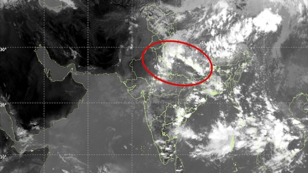

India’s southwest monsoon is entering its closing stretch with a split weather map. Fresh INSAT-3DS imagery shows thick cloud bands across northern, central and eastern India, while much of the southern peninsula has recently remained subdued. On September 6, the India Meteorological Department continued to flag heavy rain across parts of Uttarakhand, Uttar Pradesh, Madhya Pradesh and the Northeast. Longer-range guidance, however, points to a possible southward turn in rainfall after mid-September. That shift could affect late kharif crops, reservoirs, hill travel and flood risk at opposite ends of the country.
This does not mean the monsoon has already withdrawn from North India. The coming fortnight could instead become a transition period in which northern rain gradually weakens while Bay of Bengal systems become more influential.
Key Highlights
- INSAT-3DS imagery shows the monsoon still active over North, Central and East India.
- Heavy rain remains possible in Uttarakhand, Uttar Pradesh and parts of Madhya Pradesh.
- A fresh Bay of Bengal circulation could strengthen rain over eastern peninsular India.
- South Peninsular India had a 25% seasonal rainfall deficit through September 2.
- Model projections indicate North and Northwest India could turn drier around September 20.
What Do the Latest Satellite Images Show?
The satellite picture remains unmistakably monsoonal. India Today’s September 6 satellite report said INSAT-3DS images showed extensive cloud formations over northern and central India, matching IMD observations of rain over Uttarakhand, West Uttar Pradesh, West Madhya Pradesh and Sub-Himalayan West Bengal and Sikkim.
The IMD’s September 6 weather bulletin said Uttarakhand could receive widespread rain on September 6-7 and again from September 10-12. Heavy rain was also forecast over East Uttar Pradesh through September 9 and East Madhya Pradesh through September 12. Bareilly recorded 8 cm of rain between 8:30 am and 2:30 pm on Sunday.
The monsoon trough, low-pressure circulation and inland moisture are keeping the atmosphere active. These features can still generate short, intense spells even as the season nears withdrawal.
Why Is North India Still Seeing a Strong September Push?
September is the withdrawal month, but IMD does not use a fixed date. According to IMD’s southwest monsoon withdrawal criteria, withdrawal from extreme northwestern India is not considered before September 1. After that, forecasters look for five consecutive dry days, an anticyclone in the lower atmosphere and a marked reduction in moisture visible in satellite water-vapour imagery.
Those conditions are not yet established across the active rain belt. IMD’s extended-range forecast for September 3-16 said the western end of the monsoon trough may remain north of, or near, normal during September 10-16. A Western Disturbance is also expected to affect Northwest India, allowing Himalayan rainfall on some days.
The broader season has still been weak. India was 13% below its long-period average rainfall between June 1 and September 2. South Peninsular India was down 25%, while Northwest India was down 9%. Moderate El Niño conditions are present and expected to strengthen through the remaining monsoon season.
Why Could Heavy Rain Shift Towards South India After Mid-September?
The Bay of Bengal may become the main driver. IMD expects a fresh upper-air cyclonic circulation over the west-central and adjoining northwest Bay. It could develop into a low-pressure area and enhance rainfall over eastern and adjoining northeastern peninsular India during the first half of September 10-16.
Beyond that period, broader models cited by India Today suggest the active rain zone could lean farther south while North and Northwest India become comparatively drier around September 20. Coastal Karnataka, Konkan and Goa are already expected to see widespread rain during parts of the second forecast week, with scattered heavy falls possible elsewhere across the peninsula.
That puts Kerala, Karnataka, Tamil Nadu, Andhra Pradesh and Telangana on the watch list, but a widespread heavy-rain event across all five states is not confirmed. The track and strength of any Bay system will decide where the heaviest rain develops.
What Could Still Change the Forecast?
A late low-pressure area, stronger Western Disturbance or shift in the monsoon trough could change the timing. Extended forecasts show regional trends; district warnings become more reliable closer to the event. IMD also says complete southwest monsoon withdrawal from India occurs only after withdrawal from the southern peninsula, which is expected after October 1.
For farmers, reservoir managers and travellers, the next fortnight is therefore about where the monsoon’s remaining energy concentrates. North India may still face flooding, landslides and thunderstorms before the rain belt gradually favours the peninsula.
FAQs
Is the southwest monsoon withdrawing from North India now?
Not yet; active rain continues while official withdrawal requires several dry and atmospheric conditions first.
Which northern areas face heavy rain in the coming days?
Uttarakhand, Uttar Pradesh and parts of Madhya Pradesh remain among the main heavy-rain zones currently.
Why could South India receive more rain after mid-September?
Bay of Bengal systems may shift moisture southward as northern monsoon circulation becomes less active.
Does El Niño mean rain will stop completely in September?
No. El Niño can weaken seasonal rainfall, but regional low-pressure systems can trigger intense spells.
When does the southwest monsoon fully withdraw from India?
IMD declares complete withdrawal only after southern peninsular circulation changes, normally occurring after October 1.