

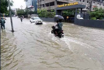

Travellers in Uttarakhand should treat hill-road plans cautiously after the India Meteorological Department issued a low-to-moderate flash-flood risk for eight districts. The warning covered Dehradun, Uttarkashi, Tehri Garhwal, Pauri Garhwal, Rudraprayag, Chamoli, Bageshwar and Pithoragarh until 11:30 am on July 31, 2026. It flagged possible surface runoff and inundation around saturated soil and low-lying neighbourhoods.
There is an important afternoon update. The latest IMD Dehradun district bulletin, issued at 1 pm, listed the flash-flood “area of concern” as nil. Yet it retained warnings for heavy rain in Uttarkashi, Rudraprayag, Bageshwar and Nainital, alongside heavy rain and lightning across hill districts. That means the earlier flash-flood window ended, but road risk has not disappeared.
What Did The Flash-Flood Bulletin Say?
The IMD national weather bulletin, released at 2:10 pm on July 30, placed a few watersheds and nearby areas in the eight districts under low-to-moderate risk. It warned that expected rainfall could produce runoff or local flooding where the ground was already saturated.
A flash-flood risk bulletin is not a statement that every district road will flood. Rain can remain highly local in the Himalayas. One valley may stay open while a nearby slope drops debris onto a highway. IMD’s updated district advice also mentions minor-to-medium landslides, rockfall, blocked or washed-out link roads, overflowing streams and waterlogging.
Which Routes Should Travellers Avoid?
No blanket closure covers every road listed below. However, non-essential travel should be postponed during heavy spells, after dark, or until police and district officials confirm movement is safe. These corridors pass through warned districts or repeatedly affected mountain terrain:
- Gangotri route: Rishikesh–Chamba–Dharasu–Uttarkashi–Harsil–Gangotri, especially narrow river-facing stretches beyond Uttarkashi.
- Yamunotri route: Dharasu–Barkot–Hanuman Chatti–Janki Chatti, where debris and stream overflow can halt vehicles.
- Kedarnath route: Rudraprayag–Agastyamuni–Guptkashi–Sonprayag–Gaurikund, including the final trek when local movement is restricted.
- Badrinath route: Srinagar–Rudraprayag–Karnaprayag–Joshimath–Badrinath, particularly known slide zones and Alaknanda-facing sections.
- Kumaon mountain roads: Bageshwar–Kapkot–Sama, Jauljibi–Munsiyari and Pithoragarh–Dharchula–Tawaghat should be avoided during downpours.
- Dehradun hill approaches: Delay trips towards Mussoorie, Sahastradhara and Chakrata when visibility drops, or streams rise.
Pilgrims can review the official Char Dham weather portal before departure. Registration does not replace a same-day road check.
Mapping apps may still show a road as open after a fresh slide. For early departures, wait for daylight and obtain confirmation from the nearest police post, especially before entering long stretches with weak mobile coverage.
Why Is Travel Risk Higher Across The Hills?
Recent disruption shows how quickly conditions can change. Heavy rain led to the temporary suspension of the Char Dham and Hemkund Sahib yatras, while 111 roads were reported shut across the state earlier this week. The pilgrimage later resumed after a two-day pause, but reopening the main yatra does not guarantee that every feeder road, trek or hotel approach remains accessible.
Traffic pressure adds another problem. Kanwar Yatra restrictions began on July 30, bringing diversions and heavier movement around Haridwar, Rishikesh, Dehradun and adjoining routes. A delayed convoy on a narrow hill road can become harder to manage when rain restarts or machinery begins clearing debris.
A recent Uttarakhand Police monsoon advisory on X asks people to avoid unnecessary journeys and remain away from rivers and drains. Travellers should follow district police accounts as closures often appear there before mapping apps update.
What Should Travellers Do Before Starting?
Check the forecast again immediately before leaving, not only the previous night. Ask the hotel, driver or local police about the exact stretch ahead. Carry drinking water, medicines, warm clothing, a charged power bank, cash and fuel. Avoid parking below cut slopes, crossing flowing water, stopping beside swollen streams or waiting beneath loose rock faces.
Use the Uttarakhand State Disaster Management Authority road-status section and emergency contacts. Call 1070 for the State Emergency Operation Centre, 1077 for district control rooms, or 112 during an immediate emergency. If officials stop vehicles, wait at the designated safe point rather than searching for an unofficial village shortcut.
Frequently Asked Questions
Which eight districts were covered by the flash-flood warning?
Dehradun, Uttarkashi, Tehri, Pauri, Rudraprayag, Chamoli, Bageshwar and Pithoragarh appeared in the warning bulletin today.
Should travellers cancel every Uttarakhand journey?
Postpone hill travel when heavy rain, lightning, landslides or fresh route closures are officially reported.
Where should tourists check route conditions?
Check IMD forecasts, Uttarakhand Police updates, district control rooms and your hotel before departure daily.
Can an open road close again the same day?
Yes, routes may reopen quickly, then close again after fresh debris, rockfall or swollen streams.
Which emergency numbers should travellers save?
Call 1070 for state emergencies, 1077 for district control rooms, or 112 for immediate assistance.