

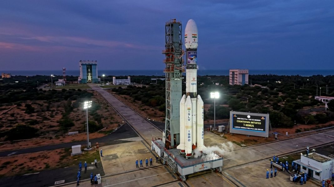

ISRO is preparing to launch EOS-05 aboard GSLV-F17 at 2:55 AM IST on September 4, 2026, from the Second Launch Pad at Satish Dhawan Space Centre, Sriharikota. The mission will send India’s first imaging satellite designed to operate from geosynchronous orbit, allowing repeated observation of a large region far more often than many low-Earth-orbit imaging satellites.
The ISRO EOS-05 launch could add a useful new layer to disaster monitoring. Frequent images can help agencies follow changing cyclones, flood spread, fire-affected terrain, crops and other environmental events without waiting long for another orbital pass.
What Is Happening With The EOS-05 Launch?
ISRO’s official GSLV-F17/EOS-05 mission page, published on August 29, confirms the launch time and says GSLV-F17 will place EOS-05 into a Sub-Geosynchronous Transfer Orbit, or Sub-GTO. The spacecraft will then continue towards its operational orbit using onboard propulsion.
GSLV-F17 is the 19th flight of India’s Geosynchronous Satellite Launch Vehicle. ISRO’s mission brochure lists the payload at about 2,367 kg and the three-stage rocket at 51.7 metres tall.
Quick launch check:
- Launch: September 4, 2026, at 2:55 AM IST
- Rocket: GSLV-F17
- Launch site: Second Launch Pad, Sriharikota
- Mission: Earth observation from geosynchronous orbit
The launch is also being watched because India’s EOS-03/GISAT-1 attempt failed in August 2021 after the cryogenic upper stage did not ignite. EOS-05 gives ISRO another opportunity to put the long-planned geo-imaging capability into service. It is also ISRO’s first orbital launch attempt since January 12, adding another layer of scrutiny.
How Will EOS-05 Track Cyclones, Floods And Forest Fires?
The key advantage is frequency. Satellites in lower orbits see a location when their path carries them overhead. A geosynchronous spacecraft keeps its orbital period synchronised with Earth’s rotation, allowing it to revisit the same broad region repeatedly and build a denser sequence of images.
For cyclones, frequent images can help forecasters and disaster teams follow cloud organisation, movement and changing coastal conditions alongside India’s meteorological satellites. For floods, repeated imaging can show how inundated areas expand, shift or recede. For forest fires, repeated observations can help track changing affected zones and smoke or heat-related signatures where sensor bands and viewing conditions permit.
ISRO’s current EOS-05 page does not publish a full sensor specification. The earlier EOS-03/GISAT mission brief, however, described the geo-imaging concept as near-real-time observation at frequent intervals for natural disasters and short-lived events, including cyclone monitoring, cloudbursts, agriculture, forestry and water bodies.
India already uses satellite inputs operationally for disasters. A March 18, 2026 Parliament reply on satellite-based disaster monitoring said ISRO and the Department of Space task Earth observation satellites for affected areas, while INSAT-3DR, INSAT-3DS and Oceansat-3 support cyclone detection, storm evolution and landfall assessment. Near-real-time inundation maps are also shared with disaster-management authorities.
Why Geosynchronous Imaging Changes The Picture
The gain is not simply another photograph. It is watching change unfold more frequently. When a river breaches an embankment or a cyclone shifts course, an older image can lose value quickly. Faster repeat observation can give response teams fresher visual evidence for evacuation planning, relief routes and field checks.
Why Is EOS-05 Different From India’s Other Earth Observation Satellites?
India already operates satellites for agriculture, oceans, mapping, weather and disaster support. EOS-05 fills a different slot by combining Earth imaging with a geosynchronous vantage point.
That makes it closer to a persistent regional watcher than a spacecraft that briefly crosses overhead. It should complement, not replace, INSAT weather satellites, radar missions and polar-orbiting remote-sensing spacecraft. Radar remains valuable when thick clouds block optical views, while weather satellites carry specialised meteorological instruments.
“Continuous watch” should not be read as a permanent live video feed. Cloud cover, daylight, sensor mode, tasking, processing and downlink schedules can affect what users receive. EOS-05 is better viewed as another layer in India’s observation network.
What Happens After Liftoff And Where Can The Launch Be Watched?
ISRO says GSLV-F17 will first inject EOS-05 into Sub-GTO. The mission brochure gives a nominal transfer-orbit apogee of 28,934 km before the spacecraft performs further orbital manoeuvres.
The mission has also reached official social channels. DD News posted the EOS-05 launch details on its official X account, while ISRO has confirmed that livestreaming begins at 2:25 AM IST, around 30 minutes before liftoff. Viewers can follow the mission through the official ISRO live-stream page.
If commissioning goes as planned, the bigger test will come after launch: how quickly EOS-05 can turn repeated regional imaging into useful information for forecasters, disaster managers and other government users.
FAQs
What is the EOS-05 launch time?
EOS-05 is scheduled to launch from Sriharikota at 2:55 AM IST on September 4, 2026.
Which rocket will launch EOS-05?
ISRO will use GSLV-F17, the nineteenth flight of India’s Geosynchronous Satellite Launch Vehicle, for EOS-05.
Why is EOS-05 called a geosynchronous imaging satellite?
Its orbit lets EOS-05 repeatedly observe the same broad region while moving closely with Earth.
Can EOS-05 help during floods?
Frequent images can show changing flood extent, supporting mapping, response planning and field verification efforts.
Will EOS-05 replace weather satellites?
No. EOS-05 will complement weather, radar and other Earth observation satellites, rather than replacing them.