
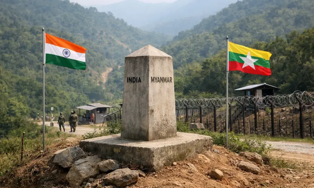

India and Myanmar are discussing unsettled stretches of their shared boundary in Manipur, but New Delhi has not confirmed that a land exchange has been approved. The debate began after reports claimed that about 1.4 square miles in Chandel district could be considered for exchange while finalising the line between Border Pillars 65 and 68.
Ministry of External Affairs spokesperson Randhir Jaiswal said on August 4, 2026, that certain border areas were still unsettled and discussions were continuing. His response confirmed active negotiations, not a completed deal. Civil society groups in Manipur have already warned against any decision that reduces the state’s territory without public consultation.
What The MEA Has Confirmed About The Reported Land Swap
The latest report on the MEA response says Jaiswal stopped short of validating the reported exchange. He acknowledged that talks were underway over sectors where the boundary remains unsettled. No final map, signed agreement, survey note or Cabinet approval has been published.
Key developments so far include:
- Reports refer to roughly 1.4 square miles of land.
- The disputed section lies between Border Pillars 65 and 68.
- The stretch is around 2.8 kilometres long.
- The location is in Chandel district near Kabaw Valley.
- MEA has confirmed talks, not an approved exchange.
- Manipur groups have demanded disclosure and local consultation.
A document cited by The Diplomat was reportedly dated May 26, 2026, and proposed completing demarcation within three months. That window points to August, although the government has not announced a deadline publicly.
Where The Manipur Border Dispute Is Located
The reported proposal concerns the Molcham sector adjoining Myanmar’s Kabaw Valley in Sagaing Region. The wider India-Myanmar boundary runs for 1,643 kilometres through Arunachal Pradesh, Nagaland, Manipur and Mizoram. Mountainous terrain, forests and settlements spread across both sides have made surveying and fencing difficult.
India’s official position has long been that there is no broad territorial dispute with Myanmar, but nine boundary pillars in the Manipur sector remain unsettled. An MHA annual report records that the Joint Boundary Working Group handles these unresolved pillars. A 2018 parliamentary reply said both governments were following the 1967 India-Myanmar Boundary Agreement.
Other sensitive stretches include Pillars 75 to 79 near Moreh and Pillars 88 to 95 near Choro Khunou. These complaints explain why residents are asking for village records, survey coordinates and historical maps before accepting any fresh alignment.
Why COCOMI Has Opposed Any Transfer Of Manipur Land
The Coordinating Committee on Manipur Integrity has said it will oppose any attempt to cede even a small part of the state. Its main objection is direct: reports identify land India may transfer, but give no clear description of territory Myanmar would return.
According to the COCOMI statement reported by Imphal Times, the organisation wants the Centre and Manipur Government to clarify the proposal before further action. It argues that border decisions cannot be treated as a technical survey alone when villages, customary land and local history may be affected.
The opposition comes during a politically fragile period in Manipur. Border fencing, migration, narcotics trafficking and armed movement from conflict-hit Myanmar are already major public concerns. A poorly explained land adjustment could trigger wider agitation even if officials describe it as a limited correction.
What Must Happen Before The Dispute Can Be Resolved
India and Myanmar still need joint surveys, agreed coordinates, verified pillar locations and a mutually accepted boundary map. Public disclosure will be critical because the word “exchange” suggests both sides must identify exactly what each country gives and receives.
Recent bilateral contact shows border security remains active on the agenda. During the 23rd India-Myanmar National Level Meeting, held in New Delhi on July 7 and 8, both sides reviewed border security, transnational crime and operational coordination. The official release did not mention a land swap, leaving the reported proposal unverified. A settled line could also remove survey delays from India’s plan to fence the entire 1,643-kilometre frontier.
For now, the dispute may be moving towards negotiation, but not necessarily resolution. A settlement will appear credible only after the Centre publishes the alignment, consults Manipur stakeholders and explains whether the proposal protects Indian territory.
Frequently Asked Questions
Has India approved a land swap with Myanmar?
No. The MEA acknowledged ongoing discussions but has not confirmed or approved any land exchange.
How much land is reportedly involved?
Reports cite around 1.4 square miles near border pillars 65 to 68 in Chandel district.
Why is the proposal controversial in Manipur?
Local groups fear territorial loss, inadequate consultation, and decisions affecting inherited village land and boundaries
What did the MEA officially say?
Spokesperson Randhir Jaiswal said unsettled border areas remain under discussion between India and Myanmar currently.
Could demarcation help border fencing?
Yes, a settled alignment could remove survey hurdles, though fencing requires separate planning and consent.